UK geographers study risks of expanding ponds on Everest glaciers
"Two young UK geographers are on a mission to the Everest to study the melting of glaciers into ponds, and eventually lakes. This process can increase glacial melt, a climate change issue in the Himalayas, and increase the risk of floods downhill..."
news.trust.org/item/20160607095310-tk3dp/

The blog of RockyGlaciers.org Content related to: debris-covered glaciers, remote sensing techniques, fieldwork, outreach materials. Contributions are welcome and will be tweeted @RockyGlaciers
Tuesday, 7 June 2016

Nepal field campaign May 2016
A team of researchers from the UK
have returned from a field campaign working on and around the Khumbu Glacier in
Nepal. The team comprised a debris-covered glacier research team including
Scott Watson and Owen King from the University of Leeds, and a rock glacier
research team including Darren Jones and Dr Stephan Harrison from the University
of Exeter.
 |
| Using a lightweight kayak (Advanced Elements Packlite) to retrieve temperature loggers deployed in a supraglacial pond |
 |
| Example bathymetry data obtained for a supraglacial pond |
 |
| The debris-covered glacier research team en route to Everest Basecamp |
Debris-covered glacier research:
Research activities
included conducting photographic surveys of ice cliffs to quantify melt rates,
obtaining bathymetric and thermal data from supraglacial ponds, and conducting
a glacier-scale photographic survey of the Khumbu Glacier to be used in a Structure-from-Motion
workflow. The team are investigating topographic change on the Khumbu Glacier
and the role of ice cliffs for glacier-scale melt.
Rock glacier research:
Research activities included a
significant clast analysis to understand landscape evolution and photographic
surveys of rock glacier features.
Other:
 |
Scott climbs Lobuche East with
and early morning Khumbu Glacier in the background.
|
Thursday, 28 April 2016
Khumbu Glacier 2016
A team of UK-based PhD students
are all set to depart to the Khumbu Glacier, home to Everest Basecamp in Nepal,
where they will spend three weeks working on and around the glacier with
Nepal-based Himalayan Research Expeditions. Their research is investigating
debris-covered glacier response to climate change and the implications for
runoff, lake formation, and hazards in the mountain environment.
Do say hi if you see them out and
about and are interested in the research. The Khumbu Glacier may resemble a
quarry from the moraines, but there are lots of processes at work! Your
photographs and observations of the glacier may also be useful for the
research.
What will they be doing?
Scott: I’ll be conducting repeat photographic surveys
of ice cliffs I photographed last year, which I’m using to build centimetre-resolution
3D models. With these I can quantify how much melt the cliffs account for and
how this varies spatially and through time. I’ll also be conducting surveys on
the glacial lakes to measure their temperature and depth variability, and collecting
measurements on glacier velocity. I’m also hoping to climb Lobuche East for a panoramic vantage point over the glacier, and to set an altitude record in a boat, conditions permitting...
Owen: I’ll be repeating
photographic surveys of the ablation zone of the Khumbu glacier to extend a
Structure from Motion (SfM) derived time series of high resolution digital
elevation models (DEMs) that our group has been collected for the past two
years. Examination of the differences between these DEMs will show us which
processes are behind glacial mass loss on this glacier. I will also be
collecting a more extensive set of ground control points (GCPs) to improve the
geolocation accuracy of satellite and aerial photography derived datasets. I
will also be verifying Captain Watson’s extreme Kayaking attempt.
Darren: I’ll be conducting
surveys of debris-covered- and rock-glaciers, both ground-based and through
kite aerial photography, with which high resolution (centimetre) 3D models will
be constructed. I’ll use this data to investigate the characteristics of the
debris-cover and gain insight into the transition of debris-covered glaciers to
rock glaciers. I will also conduct surveys on rock glacier meltwater outflow(s)
to understand the discharge volume and water quality, compared to glaciers and
debris-covered glaciers
Recent article in Outside Magazine:
www.outsideonline.com/2067651/climate-change-melting-everest
Recent publication on supraglacial ponds in the Everest region:
www.sciencedirect.com/science/article/pii/S0921818116300339
Recent publication on supraglacial ponds in the Everest region:
www.sciencedirect.com/science/article/pii/S0921818116300339

Monday, 25 April 2016
Outside Magazine interviews Rocky Glaciers researchers
Anna Callaghan of Outside Magazine recently spoke to Duncan Quincey, Scott Watson, and Owen King about past and upcoming fieldwork on the world's highest glacier. The team have been investigating how fast the Khumbu Glacier is melting and how this relates to ice cliffs and supraglacial ponds on the surface of the heavily debris-covered glacier.
The article is available at the link below:
www.outsideonline.com/2067651/climate-change-melting-everest
Anyone visiting Everest Basecamp may spot the team, who will be supported by Nepal-based Himalayan Research Expeditions, working on the Glacier from mid-May. Feel free to say hi and ask lots of questions!

Friday, 27 November 2015
BBC and other press coverage of a recent field campaign
A recent field expedition to the Khumbu Glacier by a team of researchers from the University of Leeds and the University of Sheffield was covered by the BBC. The team confirmed satellite observations that several supraglacial ponds down the easterly side of the Khumbu Glacier were coalescing to form a larger glacial lake, similar to other glaciers in the region. The Khumbu is the highest glacier in the world and is used by mountaineers for access to Mount Everest.
Other press coverage included The Washington Post, Men's Journal, and Atlas Obscura


Khumbu Glacier field campaign - Oct/Nov 2015
Summary
A team of researchers from the
University of Leeds and the University of Sheffield recently completed a four
week field campaign on the Khumbu Glacier in Nepal. The Khumbu Glacier is the
highest in the world and every year a small section of the upper glacier
becomes the home to Everest Basecamp in Nepal.
Access to the Khumbu valley was by a five day walk with two additional acclimatisation days along the Everest Basecamp trail. Our team camped just off-glacier, a short walk from a small number of trekking lodges at Lobuche. Logistical support and research permissions were organised by Himalayan Research Expeditions. Our guides were invaluable on the glacier and the kitchen team were always ready with hot food on our return!
Access to the Khumbu valley was by a five day walk with two additional acclimatisation days along the Everest Basecamp trail. Our team camped just off-glacier, a short walk from a small number of trekking lodges at Lobuche. Logistical support and research permissions were organised by Himalayan Research Expeditions. Our guides were invaluable on the glacier and the kitchen team were always ready with hot food on our return!
Data collection involved
Structure-from-Motion ice cliff surveys, GCP georeferencing, and supraglacial
pond depth surveys and instrumentation.
 | |||
| Heading along the trail |
 |
| Our campsite following snowfall |
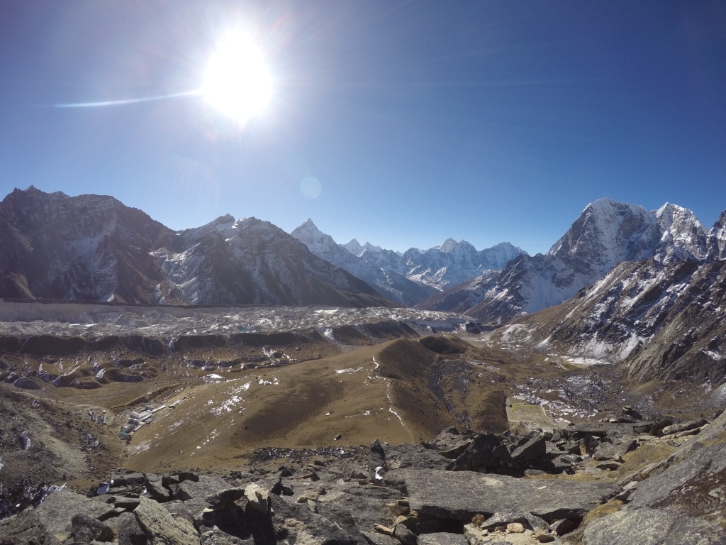 | |||||||||||
| Looking towards the Khumbu Glacier |
Background
It is widely known that Himalayan
Glaciers in this region are losing mass year on year, though the presence of
rocky debris on the surface of glaciers prolongs their response to climate
change. The debris cover, which is generally thickest at the terminus of a
glacier and becoming thinner at higher elevations, changes the spatial
distribution of maximum surface lowering, which occurs where debris is thinner
owing to the insulating effect of a thick rock cover. The ablative role of
supraglacial ponds and ice cliffs, which are widespread on such glaciers, is
little quantified. This is predominantly owing to difficult and hazardous
access for collecting field data. Ponds and ice cliffs therefore form the basis
of my research on the Khumbu Glacier.
Ongoing remote sensing analysis from fine-resolution satellite imagery is been used to reveal multi-temporal supraglacial pond dynamics by semi-automatically classifying water bodies. An increasing trend observed on other glaciers in the region is of interest and concern for several reasons. Large glacial lakes forming at the terminus of debris-covered glaciers can pose a potential outburst flood risk in some circumstances, requiring monitoring and remediation efforts to avoid a high-magnitude flood which can travel long distances downstream. Supraglacial water storage also has the potential to mitigate increases in meltwater generated under a warming climate. Ponded water also absorbs incoming solar radiation and this thermal energy is transmitted to the ice below, although this may be through a saturated sediment and debris layer. Exposed ice cliffs often exist adjacent to dynamic ponds and may feature a thin debris layer, reducing their albedo and hence increasing their capacity to melt. Capturing pond and ice cliff dynamics using satellite imagery alone is not possible, owing to revisit times, potential cloud cover and illumination issues, and cost of acquisition. Field access to the features permits surveys and instrumentation to be left in situ to allow continuous monitoring. This is particularly important in supraglacial ponds which exhibit a diurnal thermal regime and can drain englacially, transmitting the stored thermal energy into the glacial interior.
Ongoing remote sensing analysis from fine-resolution satellite imagery is been used to reveal multi-temporal supraglacial pond dynamics by semi-automatically classifying water bodies. An increasing trend observed on other glaciers in the region is of interest and concern for several reasons. Large glacial lakes forming at the terminus of debris-covered glaciers can pose a potential outburst flood risk in some circumstances, requiring monitoring and remediation efforts to avoid a high-magnitude flood which can travel long distances downstream. Supraglacial water storage also has the potential to mitigate increases in meltwater generated under a warming climate. Ponded water also absorbs incoming solar radiation and this thermal energy is transmitted to the ice below, although this may be through a saturated sediment and debris layer. Exposed ice cliffs often exist adjacent to dynamic ponds and may feature a thin debris layer, reducing their albedo and hence increasing their capacity to melt. Capturing pond and ice cliff dynamics using satellite imagery alone is not possible, owing to revisit times, potential cloud cover and illumination issues, and cost of acquisition. Field access to the features permits surveys and instrumentation to be left in situ to allow continuous monitoring. This is particularly important in supraglacial ponds which exhibit a diurnal thermal regime and can drain englacially, transmitting the stored thermal energy into the glacial interior.
Field monitoring
My field strategy involved repeat
Structure-from-Motion (SfM) surveys of ice cliffs, dGPS ground control point
identification, and the deployment and retrieval of thermistor strings and
pressure transducers in several supraglacial ponds.
Ice cliffs
Ice cliffs
SfM is a way of generating
fine-resolution 3d models of a surface using photographs from a standard camera
which are taken at different positions. The technique was implemented using
ground surveys around the ice cliff, although airborne surveys are equally
possible and are more time efficient. In this case we did not have access to an
aerial platform and helicopter traffic to Everest Basecamp would likely restrict permissions for
deployment. A range of cliff sizes, aspects, and locations was captured to
allow comparisons of melt rate and morphological evolution. Each survey
required a distribution of GCPs around the ice cliff before the photographic
survey could be undertaken. GCP markers were distributed and georeferenced with
a dGPS on the first ‘lap’ of the ice cliff. Photographs would then be taken
during one or two more circuits of the cliff to allow a range of vantage points
including high and low viewpoints. GCPs would then be collected on a final
circuit. The surface of the dynamic areas of the glacier studied were generally
rugged and unstable which limited surveys to two cliffs on a given day.
 |
| One of the ice cliffs and ponds surveyed |
GCP georeferencing
Velocity measurements of glaciers
are generally conducted using remotely sensed imagery. On debris-covered
glaciers this can be with optical or radar imagery. Typically the availability of appropriate imagery means
velocities below 10 m per year cannot be resolved and these regions are defined as
‘stagnant’. Recently it was shown using fine-resolution imagery from an
unmanned aerial vehicle that this categorisation may only loosely be applied,
since notable surface motion may still occur. During the
Khumbu field campaign I identified a number of boulders distributed in the
lower ablation area of the glacier which were georeferenced with a dGPS. A
repeat survey in May and October 2016 will reveal both horizontal and vertical
displacement, which can be used to validate remotely sensed observations since
the precision is far greater (on the order of mm - cm).
Pond surveys
Pond surveys were tailored to
assessing water storage dynamics and thermal characteristics. Thermistor
strings with temperature loggers at 1 m intervals were used to monitor temperature changes, in addition to a pressure transducer to capture water level
change. Most ponds encountered were partially frozen at the start of the field
campaign, limiting measurements of depth, which were taken with a plumb line. In
May 2016 a robotic surface water vehicle will be deployed with the aim of
obtaining fully distributed depth and temperature measurements.
 |
| Conducting a pond survey |
Most ponds were frozen on the surface by the end of the campaign,
requiring access though up to 10 cm of ice for instrument retrieval.
 |
| Instrument retrieval on a frozen pond |
Scott
Subscribe to:
Posts (Atom)